Thakek Loop Area Dam Projects by Hobo Maps - ![]()
Unique Geography of Thakhek Loop Area - the Nakai Plateau is an elevated area about 400 meters higher than the lower area near the Mekong River. The upper plateau has an abundance of water runoff from higher mountains to the north and east near the Vietnamese border. Before the construction of dams this runoff flowed unobstructed to the Mekong River via the Nam Theun and Nam Kading river systems. The location of the Nakai Plateau edge (escarpment) is shown on our Thakhek Loop Geographic Map HERE. Watershed drainage flows for the area are shown on our Drainage Map HERE.
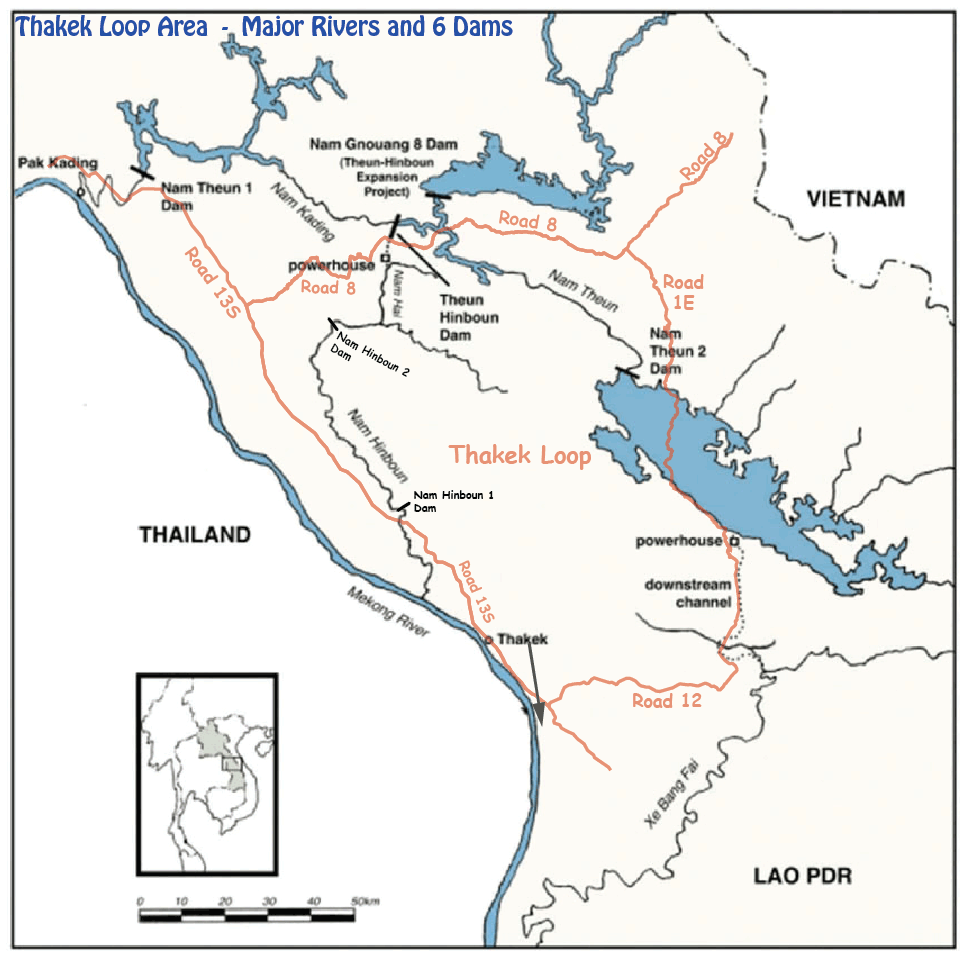
Six dams in and around Thakhek Loop area summarized below. Total output of this group is 2,200 MW - about one third of all hydropower output in Laos in 2020.
(1) The first dam near the Thakhek Loop was the Theun-Hinboun Dam finished in 1998. (2) The Nam Gnoung Dam was added in 2012 as a supplement and expansion of the Theun-Hinboun Dam system. 490 MW generating capacity
(3) Nam Theun 2 Dam was finished in 2014. 1,080 MW
(4) Nam Theun 1 Dam on Nam Kading is under construction in 2020 and expected to be completed and begin generating electricity in 2022. 644 MW
(5) Nam Hinboun Dam 1 is under construction in 2020 and expected to be completed and begin generating electricity soon. 15 MW
(6) Nam Hinboun Dam 2 (Thong Long Dam) is partially constructed in 2020 but all activity has been halted with uncertain future
Traditional style dam construction has turbines for generating electricity located in the dam wall itself and water flows directly from the reservoir through the turbines into the same river channel as before the dam. The Theun-Hinboun and Nam Theun 2 dams use a different system taking advantage of the higher elevation of the Nakai Plateau to form reservoirs at the upper level near the escarpment dropoff and channel water to turbines several kilometers away and below using the 400 meter drop in elevation to increase water pressure. Underground water channel tunnels intake water from the reservoirs far from the dam wall structures and divert the flows via downstream channels to different watersheds after passing through the turbines. These diversions create opportunities for irrigating land in areas that previously had insufficient water. The diverted water ends up flowing into the Mekong River just as before but at places further down river.
Image below shows dam projects in area of Thakhek Loop
Drainage map below shows flows of water in area surrounding the Thakhek Loop with all eventually draining into Mekong River. Each of the three colored zones is a separate watershed. Underground tunnels from two dams transfer water from the Nam Theun Watershed into the other two watersheds.

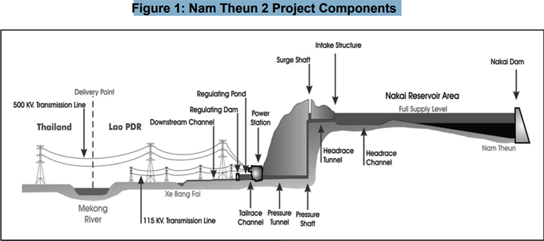
Image below shows Nam Theun 2 Project
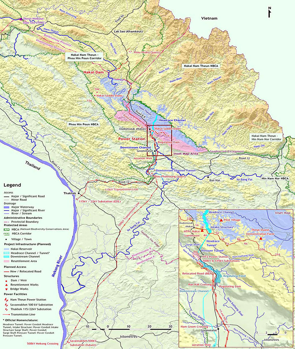
DESCRIPTION OF THE NAM THEUN 2 PROJECT - The Project dams the Nam Theun near Ban Sop Hia, Khammouane province, impounding some 195 km of the river and its tributaries and creates the Nakai reservoir on the Nakai plateau. Water from the reservoir falls about 350 meters through a tunnel to a power station located at the base of the Nakai escarpment, taking advantage of the difference in elevations between the Nakai plateau and the Gnommalat plain. From the power station, water then flows into a regulating pond and then via a 27 km downstream channel into the Xe Bang Fai (river). Water from the power station will also be released into the Nam Kathang below the regulating dam at a rate equivalent to current natural inflows. The power station has a generating capacity of 1,080 MW (net 1,070 MW), 995 MW of which will be for EGAT’s demand via a 138 km-long 500-kilovolt (kV) double-circuit transmission line. EDL will receive 75 MW for use in the Lao PDR via a 70 km-long, 115 kV transmission line to Thakhek. The total estimated cost of the Project is $1.3 billion.
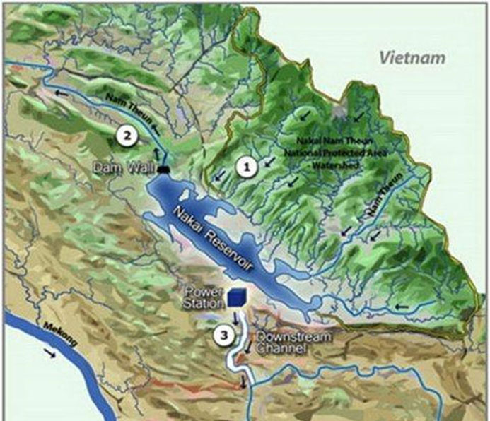
The main Project components are as follows: (i) a 48 m high dam on the Nam Theun, and 13 saddle dams to create the Nakai reservoir; (ii) 4.25 km headrace channel and intake structure on the Nakai plateau, approximately 35 km southeast of the Nakai dam to divert water from the Nakai reservoir to the power station; (iii) a power station with six electricity generating units and accompanying administration, operating, and control rooms; (iv) a regulating pond (to control downstream flows) and a 27 km long, excavated channel to direct the diverted flows from the power station into the main channel of the Xe Bang Fai near the town of Mahaxai; (v) 500 kV, 115 kV, and 22 kV transmission lines to interconnect the power station switchyards with the EGAT and EDL power transmission systems; and (vi) ancillary works such as access roads, bridges, and operators’ residences.
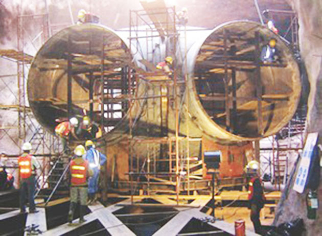
Turbine Tubes for Nam Theun 2 Project below
zzzzzzzzzzzzzzzzzzzzzzzzzzzzzzzzzzzzzzzzzzzzzzzzzzzzzzzzzzzzzzzzzzzzzzzzzzzzzzzzzzzzzzzzzzzzzzzzzzzzzzzzzzzzzzzzzzzzz
Theun Hinboun Hydropower Project
The Theun-Hinboun Hydropower Project is a 210 MW (megawat) trans-basin water diversion project located about 100 km upstream of the confluence with the Mekong that was completed in 1998. The project includes a 5.5km-long headrace tunnel (Ø 5.64m) and a 900m-long penstock, excavated by drill and blast method with access adits and a surge chamber for the installed power capacity of 2x10⁵MW. A tunnel-boring machine (TBM) was not used for this project.
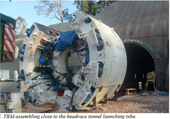
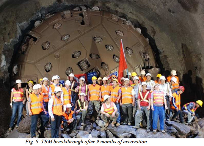
Nam Gnouang Dam - a 280-MW Theun-Hinboun Expansion project to expand the 210-MW Theun-Hinboun hydroelectric project in Khammouan Province was completed in 2012. The expansion project includes a 220-MW addition to the Theun-Hinboun power station, plus a 60-MW power plant, a six-kilometer headrace tunnel by tunnel boring machine, and a new 70-meter-tall roller-compacted-concrete dam on the Nam Gnouang River, a tributary of the Nam Theun. The new dam, 20 kilometers upstream from the existing Theun-Hinboun Dam, creates a reservoir to regulate river flows into the Theun-Hinboun headpond, increasing power output in the dry season. The waterways system between the water intake and the 220 MW powerhouse, is composed of a 5.5 km long headrace tunnel with a 110 cubic meter capacity and 6.90 meter internal diameter, a 920 meter steel penstock mainly encased with reinforced concrete and buried in trenches with a diameter varying from 5.00 m to 5.80 m, and of which 235 m are composed of an underground steel lined section. The expansion also includes a 900-meter penstock and transmission line.
Tunnel-boring machine (TBM) images below used for Theun-Hinboun Dam Expansion project (the original Theun-Hinboun Dam project in 1998 did not use a tunnel-boring machine)
