
Nam Theun 2 Dam Hydropower Info by Hobo Maps - Go to Hydropower Projects Page - - Home
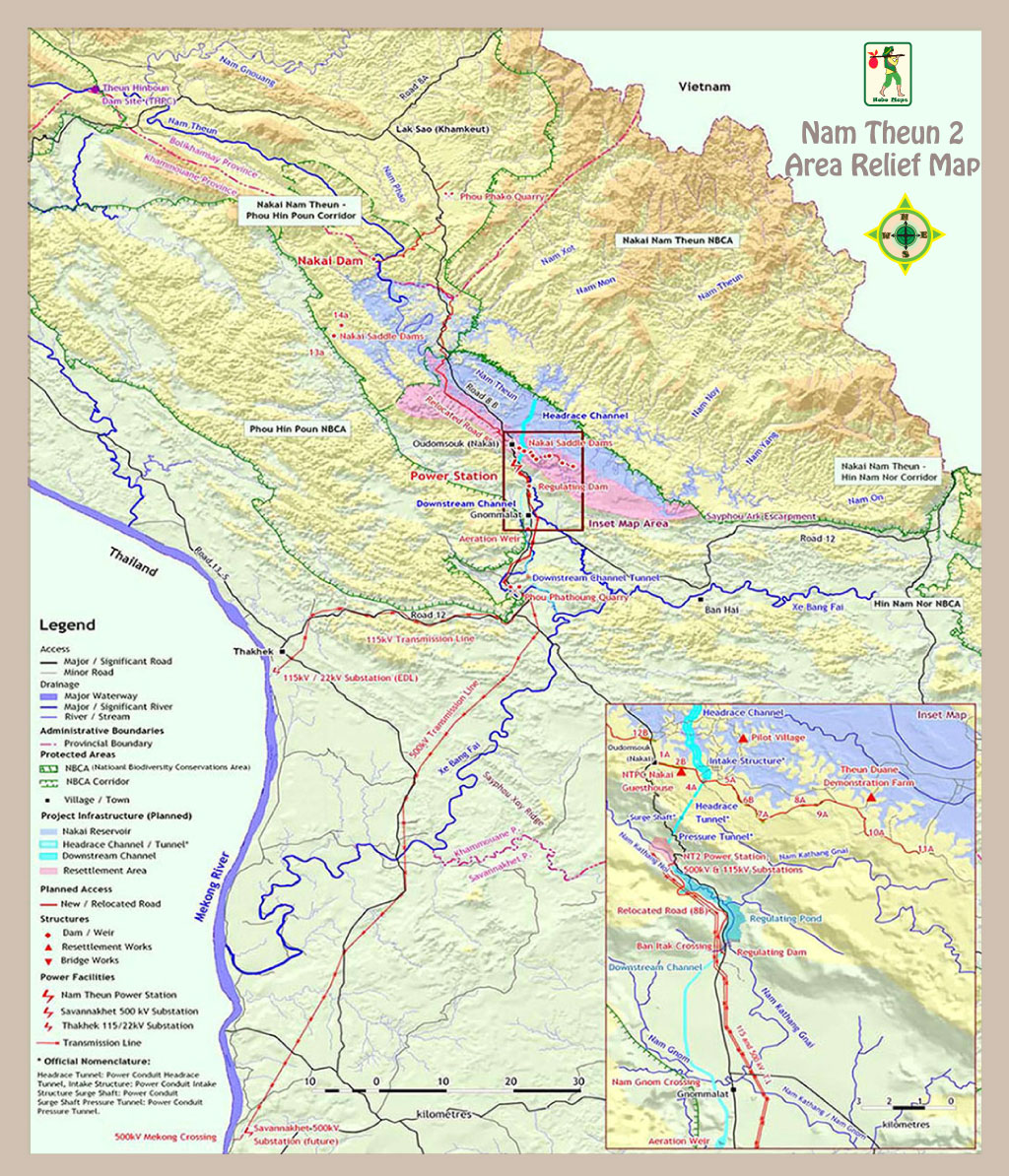
The Nam Theun 2 (NT2) hydroelectric project is located on the Nam Theun (river) in the central provinces of Khammuane and Bolikhamxay, Lao PDR. Water from the Nam Theun is dammed to form a large shallow reservoir on the Nakai plateau. A small steady flow is continuously released into the Nam Theun River downstream of the dam while most of the water is diverted into the power station.
Nam Theun 2 is pronounced as "Nam Tune Song".
Nam Theun 2 hydropower project location satellite image below:
NT2 is a trans-basin diversion project and water from the reservoir enters an intake structure near Nakai town and flows down to the powerhouse at the base of the Nakai plateau where it is discharged into the Xe Bang Fai drainage basin.
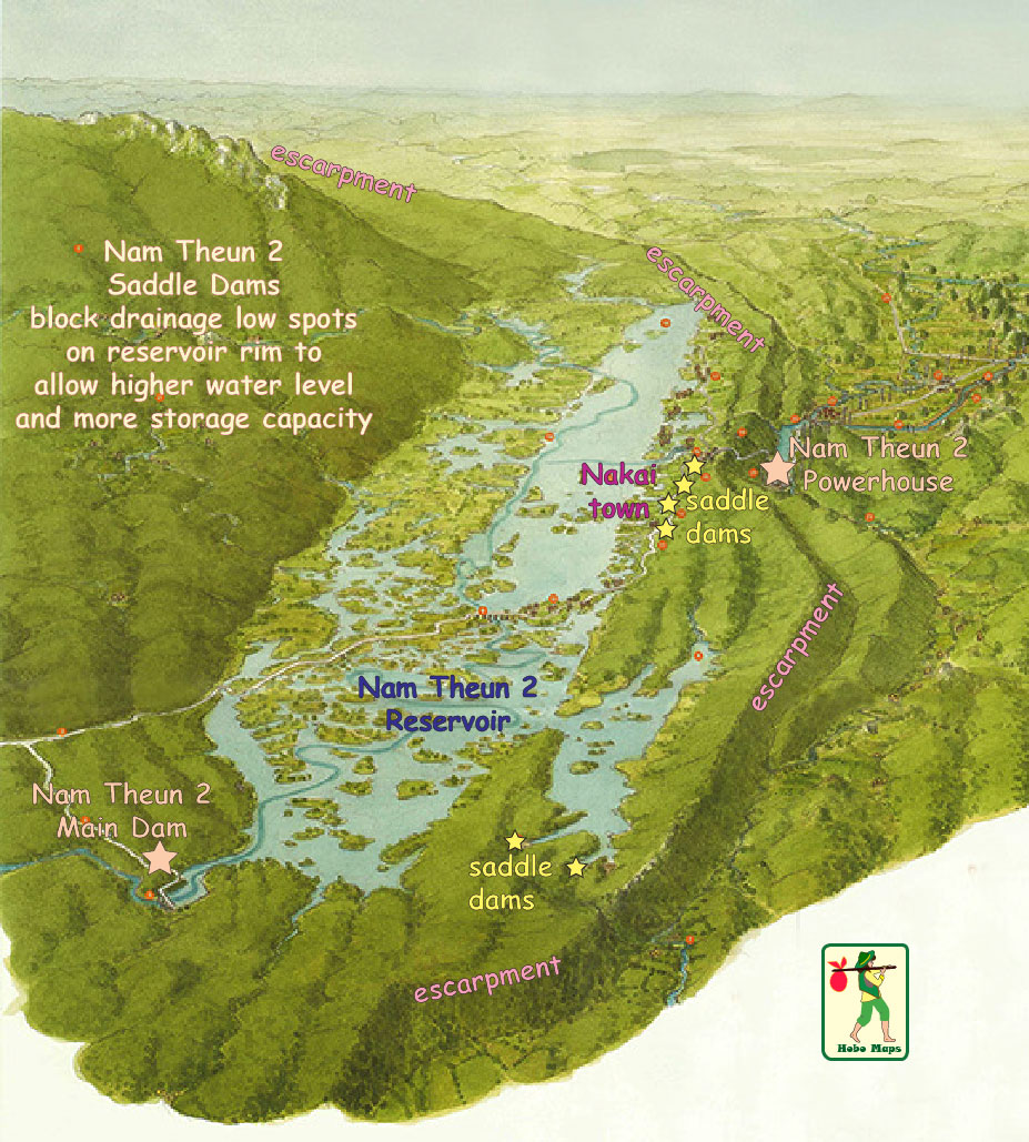
The project has one main dam and 13 smaller saddle dams that allow the reservoir surface level to be raised and storage capacity increased.
Nam Theun 2 perspective view image below looking south:
Nam Theun 2 layout image below:

The Project was developed by Nam Theun 2 Power Company Limited (NTPC) as a public-private partnership. NTPC was originaly owned by Electricite de France International (EdFI) of France (35%), Electricity Generating Public Company (EGCO) of Thailand (25%), Italian Thai Development Public Company Limited (ITD) of Thailand (15%) and the Government of Lao PDR (25%) held by Lao Holding State Enterprise (LHSE).
Later reports have ownership shares as EDF Nam Theun Holding (40%), EGCO (35%) & LHSE (25%)
The project was developed as a build-own-operate-transfer project with the Lao government granting a 25-year concession to operate the project after which full ownership will transfer to the government at no cost. The project began commercial operations in March 2010.
Main features of NT2 project in profile view below:

Estimated cost for the project was US $1.45 billion financed by a combination of loans and contingency financing of about US $1.1 billion and shareholder equity of about $350 million. Asian Development Bank (ADB) was active in helping to arrange the financing and provided a startup loan to the Lao government. Project costs include the $1.25 billion base cost plus $200 million in contingency funding. Financing involved International Institutions such as ADB, Export Credit Agencies and multiple commercial lenders.
The project is rated at 1,070 MW with annual output capacity of 5,500 gigawatt-hours (GWh). The original plan was to export annually about 5,300 GWh to Thailand and about 200-300 GWh to EDL for consumption in Laos. In Sept. 2025 it was announced that NT2 would be increasing the amount of power sold to EDL for domestic consumption from 300 to 500 GWh.
It was estimated the project could generate about US $1.9 billion revenue for the Lao Government over the 25-year concession period.
Nam Theun 2 (NT2) dam site satellite image below at coordinates - 17°59'51.6"N 104°57'15.4"E (17.997667, 104.954278)

Nam Theun 2 dam structure images below. This dam is about 35 km distance from the NT2 powerhouse which is near the other end of the reservoir to take advantage of a steep drop in elevation down to the powerhouse.


The Nakai reservoir surface covers more than 450 square km at full supply level at 538 meters above sea level and just 86 square km at minimum operating level. The Nam Theun watershed basin covers about 4,039 square km.
The reservoir is called Nakai Reservoir or Nam Theun 2 Reservoir or NT2 Reservoir. Its volume capacity is the second largest in Laos after Nam Ngum 1 Reservoir. Total storage capacity is 3.9 billion cubic meters with an active volume of 3.6 billion cubic meters, leaving only .3 billion as dead volume. NT2 reservoir is about 80 km long and mostly shallow with an average depth of 8 meters and 39 meters maximum depth.
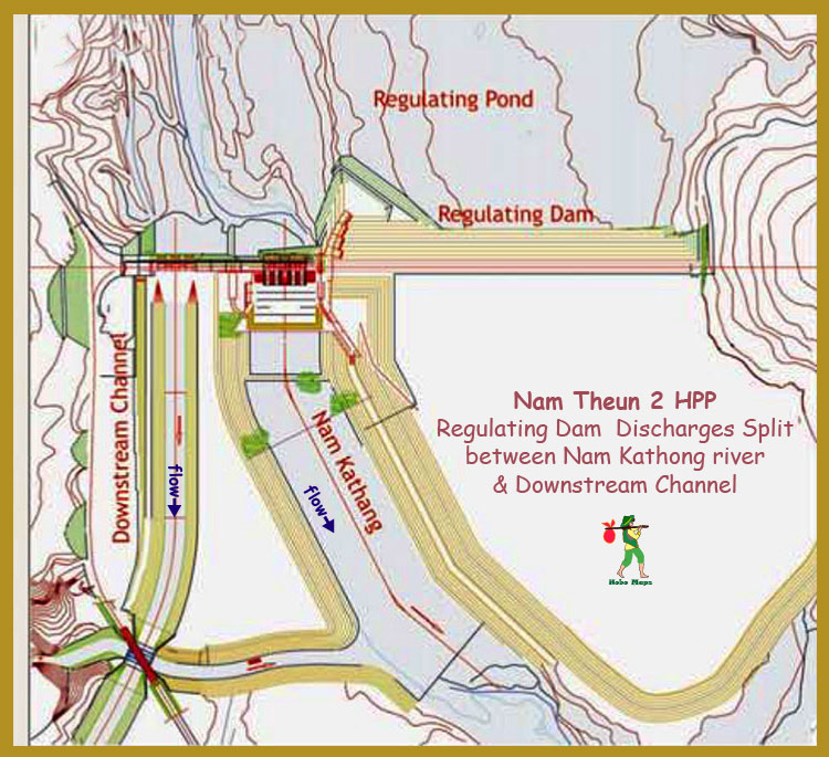
Water from the reservoir drops 363 meters down to a powerhouse at the base of the Nakai plateau near the town of Gnommalat. Water discharged from the powerhouse flows along a 27 km-long open channel to the Xe Bang Fai (river) which flows into the Mekong. A regulating dam and pond downstream of the powerhouse ensure the smooth release of water into downstream water courses.

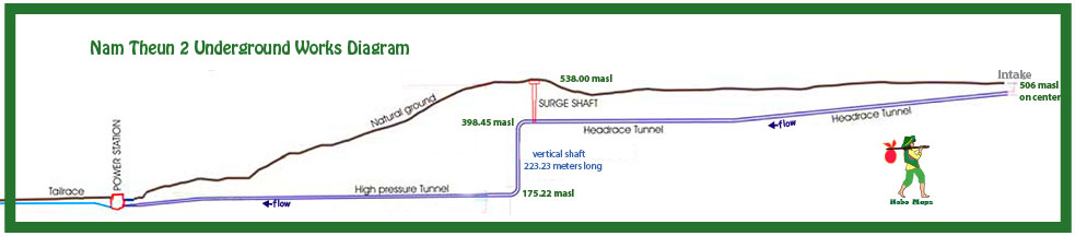
Water from the intake structure flows into a reinforced concrete headrace tunnel (1500 meters long and 9.2 meters diameter), then to a vertical pressure shaft (vertical drop of 223.75 meters, diameter 8.8 meters) down through the rock escarpment dropping about 363 meters in elevation from the reservoir and finally through a horizontal pressure tunnel 1142 meters long to reach the power station.
The Headrace section has a slope of 0.5% with typical water pressure of 11.5 bars and velocity at 4.7 meters per second.
The high-pressure Penstock is 7.15 meters in diameter with a slope of 1.1%. Typical pressure is at 34 bars with water velocity at 7.8 meters per second.
Andritz Hydro provided design and supply of electro-mechanical equipment for the project.
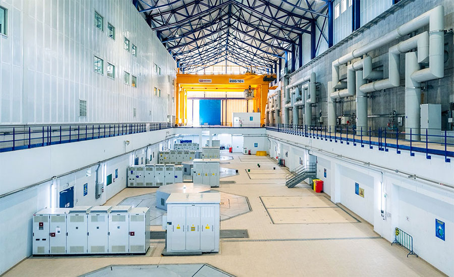
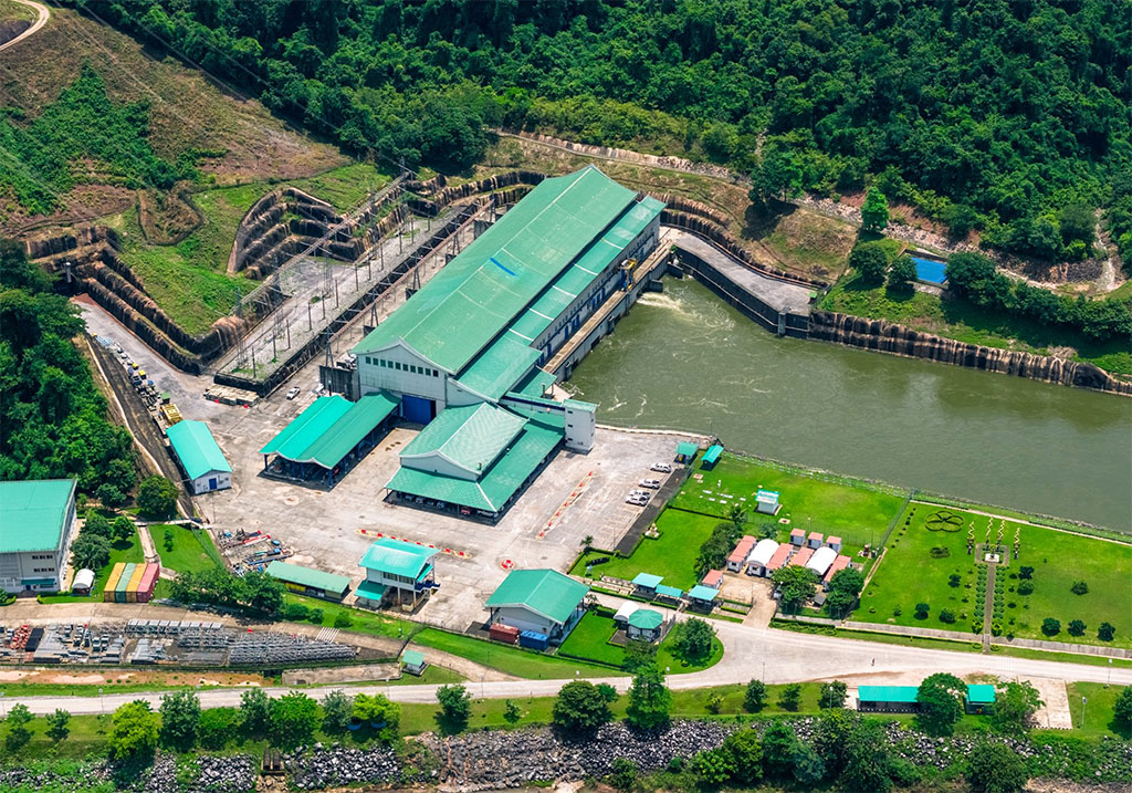
The Power House (images below) has four Francis turbines (total 996.5 MW) and two Pelton turbines (total 75 MW).

Nam Theun 2 vertical Francis reaction turbine image below.

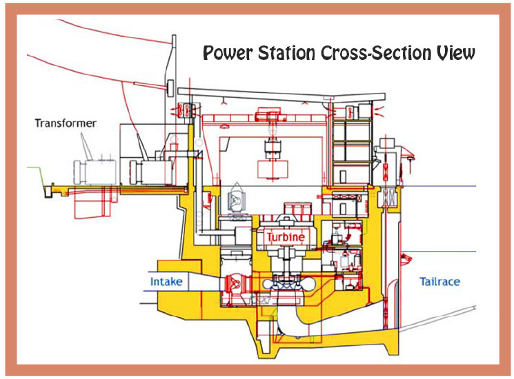
Water passing through the power house is discharged through a 340 meter-long tailrace channel into a regulating pond. From the regulating pond, water is released into a 27 kilometer-long downstream channel that flows into the Xe Bang Fai River which eventually joins the Mekong River south of Thakhek town.
The project required the relocation of about 17 villages and 6,200 people, predominantly ethnic minorities.
Nam Theun 2 area relief map location and details in image below:
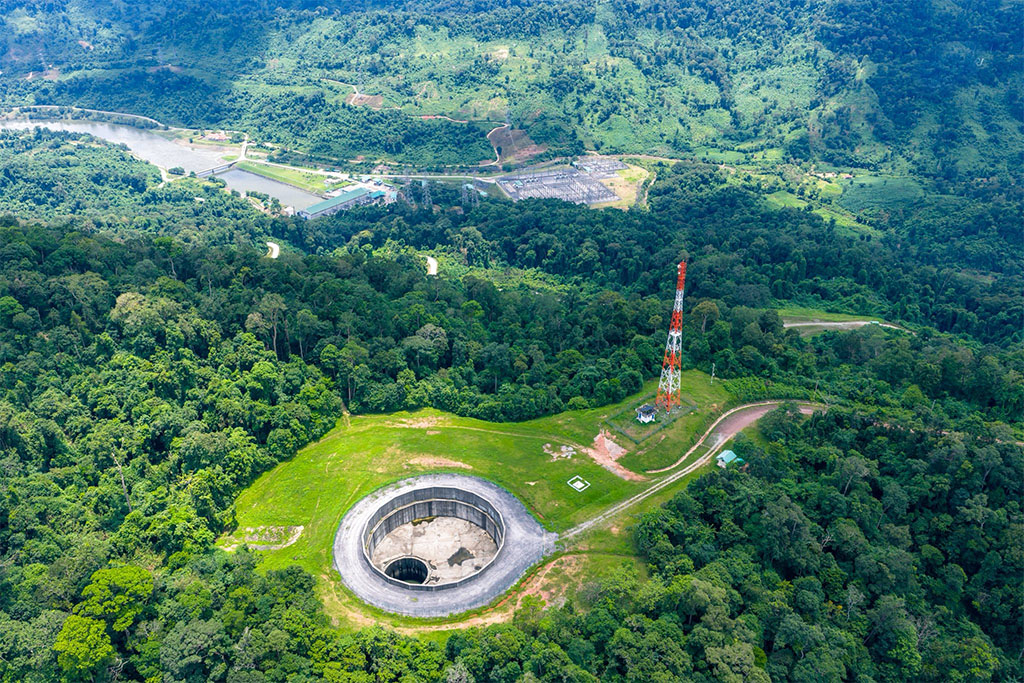
Nam Theun 2 powerhouse area and regulating pond image below at coordinates - 17°40'45.9"N 105°09'12.7"E (17.679403, 105.153526). Bottom left corner shows the top of the surge tank shaft (109 meters high and 8.8 meters in diameter).

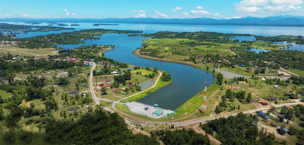
Nam Theun 2 upriver view image below looking north:

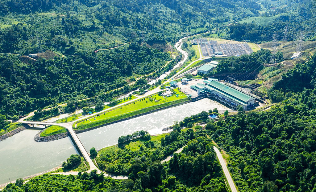
Nam Theun 2 plant site images below:

Nam Theun 2 dark blue tiny intake structure near Nakai town in image below:
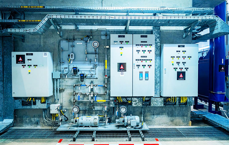
Nam Theun 2 controls images below:


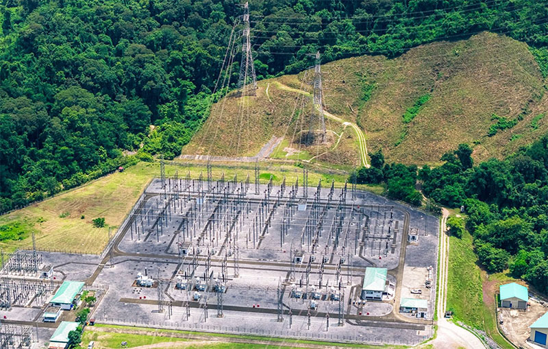
Switchyard image below:
NT2 reservoir expands and contracts with the wet and dry seasons as illustrated below:

Good info at NT2 Visitor Center in red-roof building below - not far below and south of Nakai town on National Road 1E


NamTheun 2 aerial view video 9/12/2017 - HERE .
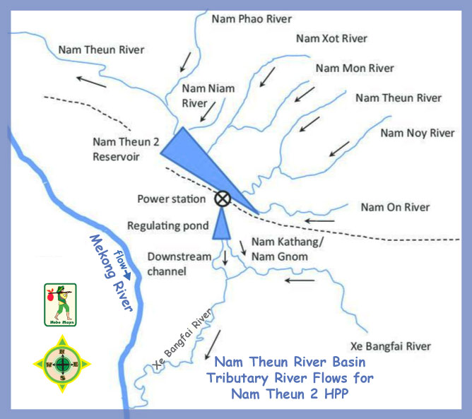
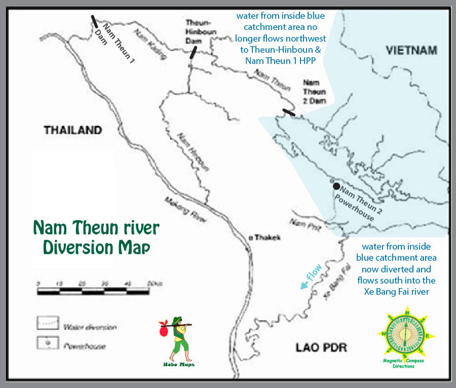
Inter Basin Water Diversions:
The Nam Theun (river) historically had all of its water flow into the Nam Kading (river) which joins the Mekong near Pak Kading. The Nam Theun 2 Hydropower project diverted much of the Nam Theun flow into the Xe Bang Fai (river) which joins the Mekong south of Thakhek town. This diversion has decreased the natural Mekong flow along about 190 km of its length between where the Nam Kading and Xe Bang Fai rivers join the Mekong.
The Theun-Hinboun Hydropower project has also diverted waters from the Nam Theun (river) and from the Nam Gnouang (river) into the Nam Hinboun (river) which joins the Mekong near Hinboun town. This diversion has decreased the Mekong flow even more along the 93 km distance between where the Nam Kading and Nam Hinboun rivers join the Mekong.
The natural flow of the Mekong past the Thakhek Loop area is now greatly reduced by the amount of these two inter-basin diversions. See our Thakhek Area Drainage Map for more detailed info regarding these diversions.
Nam Theun 2 powerhouse discharged water flows from the regulating pond into a 16 km-long concrete channel that brings irrigation benefits to adjacent lands.

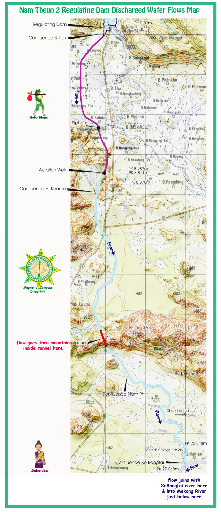
An aeration weir system below.

A 600 meter-long tunnel takes the downstream channel through a karst mountain below.

Nam Theun 2 project shown in yellow oval area on right side of map below. The intake structure near Nakai town is about 40 km southeast of the dam structure.


Nam Theun 2 History
1993 - Agreement is signed between the government of Lao PDR and
private sponsors to develop the project with
World Bank guidelines.
1997 - First series of environmental and social safeguards documents produced.
1997-1998 - Asian financial crisis forces the governments of Lao PDR and Thailand to delay development of the project.
May 2000 - EGAT and Nam Theun 2 Electricity Company (NTEC) agree on a proposed electricity tariff.
September 2001 - Shareholders agreement signed.
September 2002 - NTEC and government of Loa PDR create Nam Theun 2 Power Company (NTPC) as a Lao company.
October 2002 - Concession agreement signed.
November 2003 - Power purchase agreements signed with EGAT and EDL.
2004 - Completion of safeguard documents and project financing.
June 2005 - Financial close, beginning of full construction activities and implementation of social and environmental programs.
April 2006-April 2008 - Construction of resettlement villages and relocation of villagers to new homes.
August and October 2007 - First partial and temporary impoundment of the reservoir (80 sq km).
March 2008 - Completion of diversion tunnel concrete works.
April 2008 - Closure of diversion tunnel and beginning of impoundment.
June 2008 - Tunnel filling test.
August 2008 - Spillway gates closed on Nakai dam.
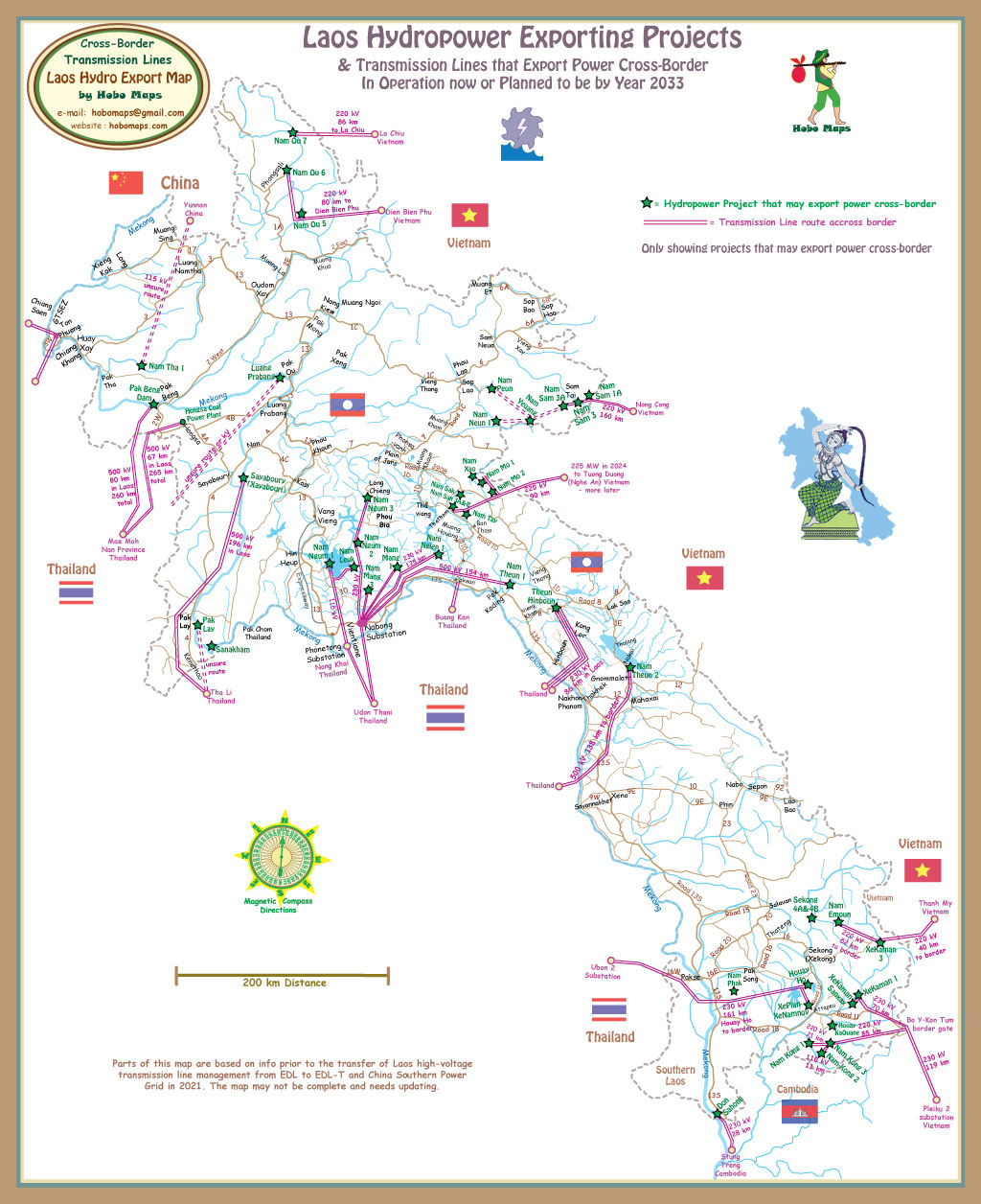
March 2010 - Commercial export of electricity to Thailand begins.
Transmission Line to Thailand
A 115 kV double circuit transmission line goes to Mahaxai in Lao PDR and a 138 kilometer long 500 kV double-circuit transmission line goes to the Thailand border for export to EGAT along the route seen in map below: See enlarged version HERE
Nam Theun 2 Solar Project
In 2020 the Lao government and shareholders in the Nam Theun 2 hydropower project agreed to develop Nam Theun 2-Solar on the reservoir of Nam Theun 2. It would be one of the largest hybrid floating solar projects in the world with solar panels covering an area of 3.2 square kilometres (less than 1 percent of the reservoir’s surface area at full supply level).
As of year 2025 we aren't aware of any solar units actually having been installed.