
Nam Tha 2 Had Muak Dam Hydropower info by Hobo Maps - Go to Hydropower Projects Page - - Home
Nam Tha is pronounced like "Nam tah".
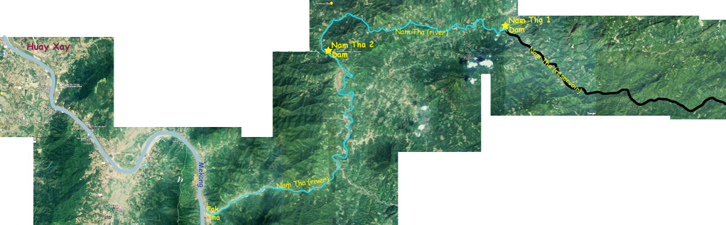
Nam Tha 2 Hydropower Project is located on the Nam Tha river about 30 km upstream from where the river joins the Mekong. The project is near Ban Hat Mouak in Pha Oudom district of Bokeo Province of northern Lao PDR.
The project is also known as - Had Muak, Nam Tha 2 (B. Hat Mouak), Hat Muak and Namtra Hard Mouk (on Google Maps)
The Nam Tha river begins in northern Laos near the Lao-China border and runs southwest to join the Mekong just south of Houay Xay near Pak Tha village in Bokeo Province on the Lao-Thai border.
The Nam Tha 2 Had Muak dam and powerhouse are located together at coordinates 20°14'34.7"N 100°42'43.1"E (20.242972, 100.711972) as seen in the satellite images below.

The project owner may be Nam Tha Hat Muak Hydropower Co., but we aren't sure.
The project is developed by Huamchai Phathana pursuant to a MOU dated 9/7/2015. Huamchai Phathana was also the developer of the Nam Tha 3 hydropower project that went online in 2011.
Looks like a resettlement area has been developed just south of the hydropower facility as seen in satellite image below.

In 2026 the project seems to be completed and in operation as seen in satellite image below.

The project is a run-of-river type without a large reservoir.
The project capacity is 37.5 MW with expected annual output of 170 GWh.
The project output is to be sold to EDL for domestic consumption by a 18 km long single circuit 115 kV transmission line.
Satellite image below shows locations of both Nam Tha 1 and Nam Tha 2 hydropower projects.
On September 10, 2024 we see very strong releasing of water from the reservoir after heavy rains in the videos and images below.
https://www.facebook.com/100025249673471/videos/pcb.1421186358733006/1042682350572952
https://www.facebook.com/100025249673471/videos/1106293374255789/


