Nam Sor Dam Hydropower info by Hobo Maps- Go to Hydropower Projects Page - - Home

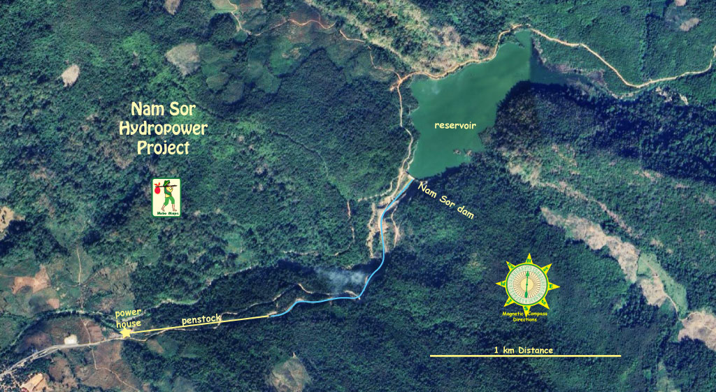
Nam Sor Hydropower Project is located in Viengthong District, Bolikhamxay Province, Lao PDR. The project dam site is on the Nam Sor (river) which is a tributary of Nam Nagom (river) about 6 km upstream from their confluence at Ban Phadeng

The Nam Sor Hydropower Project location is shown in satellite images below:

The project is owned by Nam Sor Hydropower Company with 4 main shareholders: Vieng Chantech Construction Co., Ltd. (20%), Prixay Thailand (38%), CSS (38%) and V-Hydro Holding Company (4%)

The project is developed by Vientiane Techno Co., Ltd. as EPC contractor and was under construction in year 2023.

The project is a run-of-river hydropower station with installed capacity of 4.2 MW (2×2.1 MW Horizontal Francis) with annual 19 GWh power supply capacity. The power generated is to be delivered to EDL.

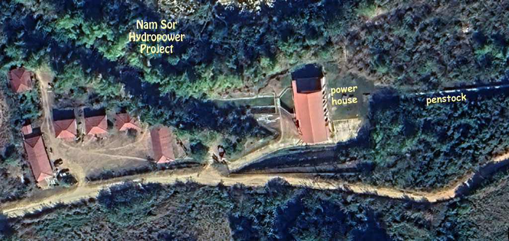
Nam Sor Powerhouse is located at coordinates 18°36'17.8"N 104°27'14.4"E (18.604944, 104.454000) below:

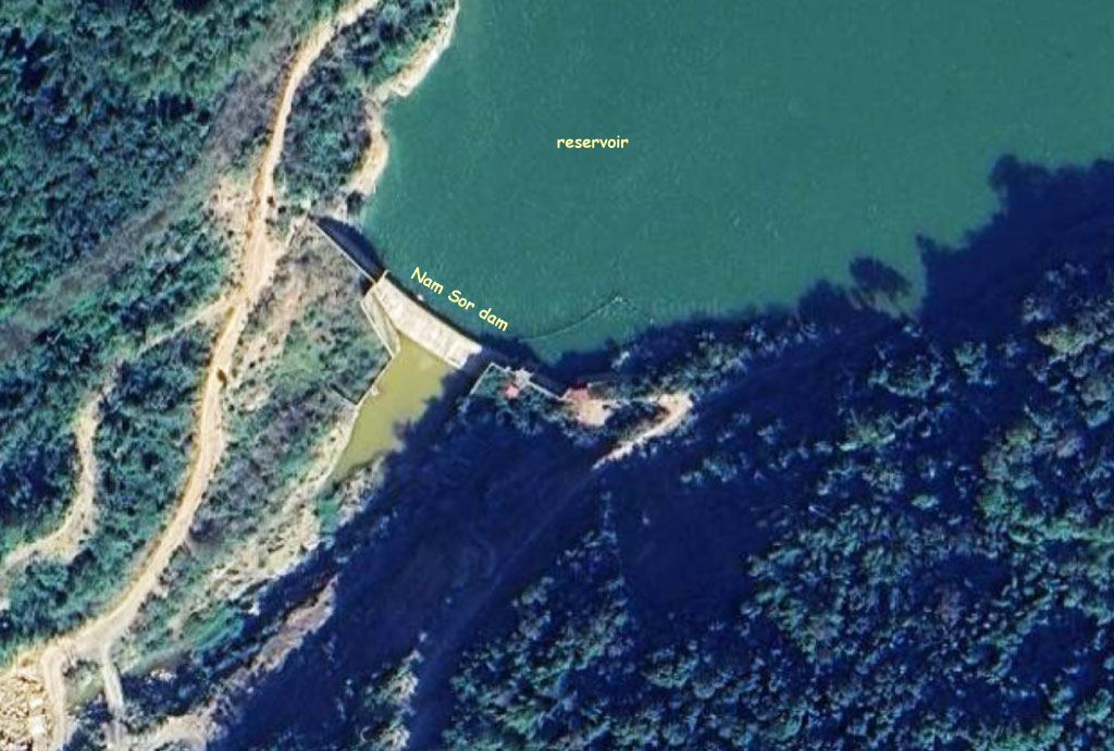
Nam Sor Dam is located at coordinates 18°36'43.2"N 104°28'06.5"E (18.612008, 104.468459) below:

The project includes a backfill R.C Concrete dam, reservoir, fixed weir, sand trap, intake, 1300 meter long headrace canal, headrace tunnel, forebay, 800 meter long penstock, powerhouse, 12 km long high voltage transmission line, spillway and a tailrace.

The project has gross head of 128 meters.

Nam Sor Dam description and project layout image below:

Nam Sor Dam project layout image below:

Nam Sor & Nam Ngom Hydropower Projects are close together as seen in topographic map below:

Nam Sor HPP catchment area outlined below:

Nam Sor Dam reservoir imge below:

Nam Sor Dam penstock images below:

Nam Sor Dam power plant image below:

Nam Sor Dam power plant images below:

Nam Sor Dam powerhouse control panel image below:

Nam Sor switchyard image below:

Nam Sor construction images below:

The Nam Sor Hydropower project may have qualified as a Clean Development Mechanism (CDM) project under the Kyoto Protocol allowing it to receive carbon emission reduction credits. The project will help result in CO2 emission reduction as its output may displace power generation that otherwise would be based on combustion of fossil fuels. The reduction in carbon dioxide emissions is estimated to be 10,630 tons per year. View or download the CDM application document HERE . This CDM application was filed a few years before completion of the project and we aren't sure if it actually came into effect as the Kyoto Protocol system benefits may have expired in the interim.

----------------

Info below copied in 2024 from Lao Blogger website at - https://lao-hydropower.blogspot.com/2021/06/namsor-power-plant.html .

Location:  Dam site on the Nam Sor River, a Tributary of Nam Gnom, about 6 km
                             Upstream from the confluence

 Main Hydrological Data
-       River system                                   Run-of-River
-       Grid type                                        Central Grid (Connect to EDL grid)
-       Design flows                                  3.5 m3/s(rated) and 4.8  m3/s (Maximum)
-       Gross Head                                     127.85 m
-       Catchment area                               85 km2, at the dam site, Level 522 m
-       Annual basin rainfall                      2,400 mm
-       Annual evapotranspiration            877.8 mm
-       Mean river discharge                      3.60 m3/s
-       Mean annual discharge                  113.53 x10⁶ m3
 Reservoir and water level
-       Type                                                Storage
·      Water level:
-       Full supply level (FSL)                  522 m a.s.l.
-       Minimum operation level               518 m a.s.l.
-       Maximum flood level (PMF)         526 m a.s.l.
 ·      Reservoir
-          Surface area at an elevation 522 m a.s.l.                   11.82 ha
-          Volume at elevation 522 m a.a.l.                          0.261 x 10⁶ m3
-          Active storage (ei. 522 – 518 m a.s.l.)                  0.235 x 10⁶ m3
-          Volume below intake invert                                 0.027 x 10⁶ m3
-          Dead storage (below el. 518 m a.s.l.)                   0.027 x 10⁶ m3
 Power generation
-          Head (gross, static)                                               127.85 m  
-          Net head                                                                120.43 m  
-          Installed capacity  in the range                             4.8 MW = (2 x 2.4 MW)
-          While firm capacity                                              0.6 - 0.9  MW 
-          annual energy between                                         20 – 23 Gwh/year
Dam
-          Type                                              Backfill Concrete R.C Concrete
-          Crest elevation                              522 m a.s.l.
-          River bed elevation                       510 m a.s.l.
-          Maximum height                          14 m
-          Crest length                                   52 m (including spillway)
-          Crest width                                   14.40 m
-          Concrete volume                           6014 m3 (without power house)
Spillway
-          Inflow flood peaks:
Q100                                     515 m3/s
Qspill                                      485m3/s
PMF                                      2,140m3/s
-          Max. outflow                                487.3 m3/s
-          Type of gates                                Vertical sliding
-          Design head                                  5.00 m
-          Ogee crests elevation                    522 m a.s.l.
-          Width of piers                               30 m
-          Crest length                                   29.4 m
 Outlet
-          Gate size                                        1.5 x1.5 (H x W)
-          Estimate of sediment bad load      80 ton/km2/year (2,500-3,000 m3)
Headrace Channel
-          Flow rate (max)                                                    4.8m3/sec
-          Flow rate (rated)                                                   3.5m3/sec
-          Section of U canal w x h                                      2.00 m x 1.70 m
-          Bottom slope                                                        1/1000
-          Canal Length                                                        1,300 m
-          Water Depth (Q = 4.3 m3/s)                                  1.30 m
-          Water Depth (Q = 3.6 m3/s)                                  1.13 m
-          Velocity (Q = 4.3 m3/s)                                        1.66 m/s
-          Velocity(Q = 3.6 m3/s)                                         1.59 m/s
Forebay and Penstock Intake
-          Normal Operating Level                                       518.00 m
-          Crest  max                                                             518.20 m
-          Crest min                                                              516.5 m
-          Qrated                                                                     3.50m3/sec
-          Qmax                                                                      4.8m3/sec
-          Fore bay Dimensions                                            8 m x 20m x 3m
-          Flushing Duck                                                      0.50 m x 0.83 m
-          Over flow side spillway                                        15 m
 Penstock Pipe
-          Steel pipe (length)                                                800 m
-          Designed diameter                                                1.2 m
-          Thickness of rack bars                                          12 mm
-          Max design discharges                                         4.4 m3/sec
-          Height of trash rack at max EL                            2,400 mm
-          Width of trash rack                                               2,200 mm
-          Gross surface Area                                               5.28 m2
-          Velocity                                                                0.80 m/s
-          Clearance between rack bars                                75 mm
-          Angle of bars with horizontal                               66 degrees
-          Channel width                                                      1,875 mm
-          Number of rack bars                                             24.4 no
-          Approach Velocity through rack                          1.0 m/s                       
 Power House
-          Location                                                                Ban Meexay
-          Type                                                                      surface, reinforced concrete structure
-          Dimensions                                                           10.5m x16m x23 m (H xW x L)
-          EL floor                                                                391.00  m.a.s.l
-          Number of units                                                    2
-          Turbine axis elevation                                          389.75 m a.s.l.
-          Spacing of units                                                    8.5 m
-          Tail water level:
Max tail water level (nature)                        390.35 m a.s.l.
Normal tail water level (nature)                    390.23m a.s.l.
Minimum tail water level (nature)               390.10 m a.s.l.
 Power Generating Equipment
-          Turbines
Type                                                              Horizontal Francis
Rated discharge per unit                               1.75-2.40 m3/s
Rated output per unit                                    2.4 MW
Rated net head                                              120.43 m
-          Speed                                                                    750 r/min
-          Output                                                                   2190 kw
-          Generators:                                                            (Type Horizontal synchronous)
No of pole                                                    8
Output                                                         2200KVA
Frequency                                                    50 Hz
Voltage                                                        606 kv
Power factor                                                0.9
Transmission Line
-          Nominal voltage                                                   22 kV
-          Type                                                                      two overhead double circuit lines
-          Length                                                                   12  km