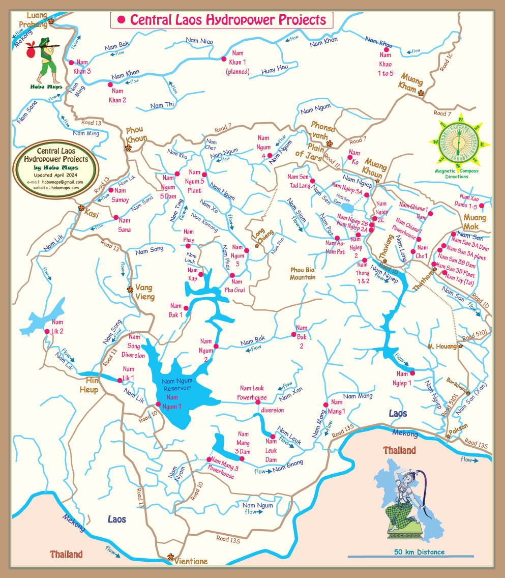
Nam Ko Xieng Khouang Dam and Reservoir Info - by Hobo Maps - Go to Hydropower Projects Page - - - HOME
There are two rivers in northern Laos called Nam Ko and since both have dams and reservoirs with hydropower capacity we have separate web pages for each. The first is a small operating 1.5 MW hyropower project in Oudomxay Province with our web page for that project at Nam Ko Oudomxay Dam.
The other Nam Ko river reservoir project is in Xieng Khouang Province southeast of the Plain of Jars and the rest of this web below is about this Nam Ko Dam & Reservoir.
From satellite images we see that a new dam and reservoir has been developed at the headwaters of the Nam Ko river in Xieng Khouang Province but we haven't found any info on the web to indicate a name for this project or what the project is used for.
It seems this reservoir is not directly related to a specific hydropower project but may be an upstream storage pond for multiple downriver hydropower projects.
Since the dam is on the headwaters of Nam Ko river we will refer to it as the Nam Ko Dam and Reservoir until we discover the actual name.
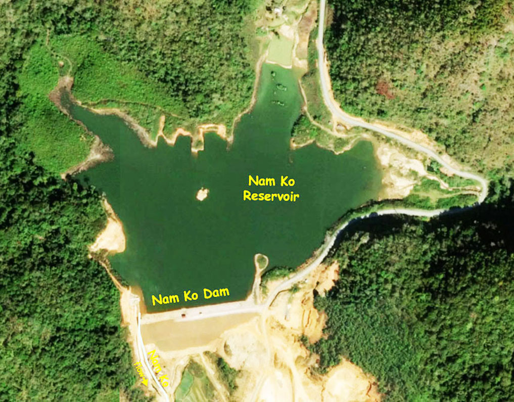
The project is shown on the satellite image below at coordinates 19°24'16.3"N 103°16'27.0"E (19.404518, 103.274163).
Nam Ko Dam & Reservoir are in upper right of image below with National Road 1D at the bottom and Nam Ko river in between.

Our best guess is that this mysterious reservoir is intended to be an upriver water retention and storage reservoir to hold back water in the wet season for later release in the dry season to power turbines at three existing major hydropower projects south of there in the Nam Ngiep river basin (Nam Ngiep 1, Nam Ngiep 2 & Nam Ngeip 3A).
The Nam Ngiep river headwaters are located on the Xieng Khouang plateau southeast of Phonsavanh and a bit north of National Road 1D in Xieng Khouang Province, Lao PDR.
The Nam Ko river and another nearby river seem to be the two tributaries that form the beginning of the Nam Ngiep river where they meet just north of the km 16 marker of National Road 1D at coordinates 19°22'56.6"N 103°14'53.7"E (19.382398, 103.248240) as shown in the image below.
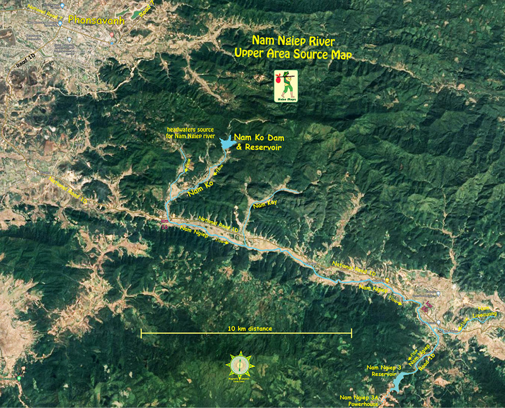
The released waters from the Nam Ko Reservoir would flow down the Nam Ko river into the Nam Ngiep river which then flows east along Road 1D to Muang Khoun town and then south into the Nam Ngiep 3 reservoir and into the nearby Nam Ngiep 3A powerhouse.
From there the water would flow down a 10.9 km underground conduit to the Nam Sen Reservoir.
From the Nam Sen reservoir another undergound conduit takes water down to the Nam Ngiep 2 powerhouse located on the Nam Siam river and then released into the Nam Siam river that merges with the Nam Ngiep river nearby.
From there the Nam Ngiep flows east and south into the Nam Ngiep 1 reservoir where eventually the water would pass thru the Nam Ngiep 1 powerhouse.
The final journey would take the released water down the Nam Ngiep river which joins the Mekong River near Paksan town.
This dam makes sense as an economical way to generate more clean and green energy by better utilizing existing infrastructure.
Nam Ko Dam & Reservoir location shown on upper right of map below: