
Nam Chiane 1 Dam (Nam Chian 1) Hydropower project in Laos by Hobo Maps- Go to Hydropower Projects Page - - - HOME
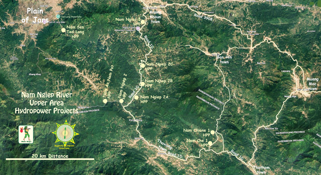
Nam Chiane 1 Hydropower project is located on the upper Nam Chiane (river) in central Laos. Nam Chiane is a tributary of the Nam Ngiep (river) which joins the Mekong river near Paksan.
The project is about 70 km southeast of Phonsavanh and the Plain of Jars and just a few km above National Road 1D as it goes south towards Paksan and the Mekong.
Nam Chiane is also known as Nam Chian, Nam Chiean and Nam Chien.
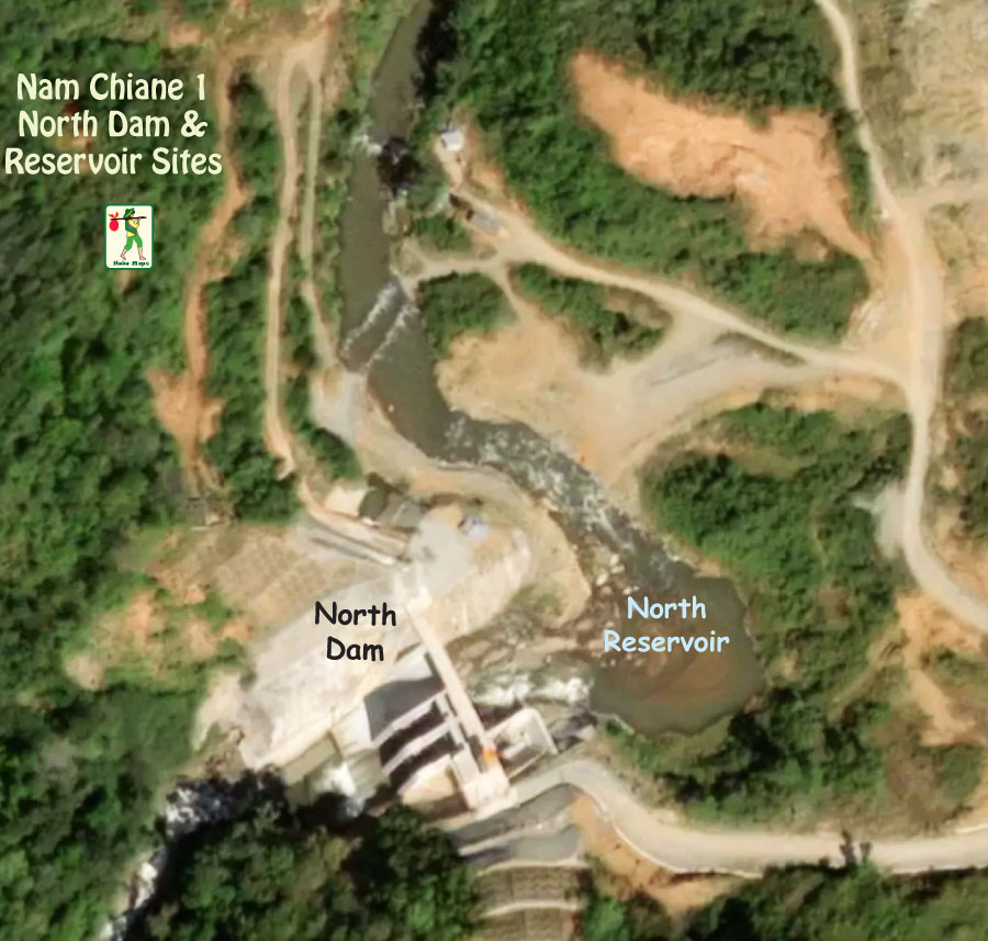
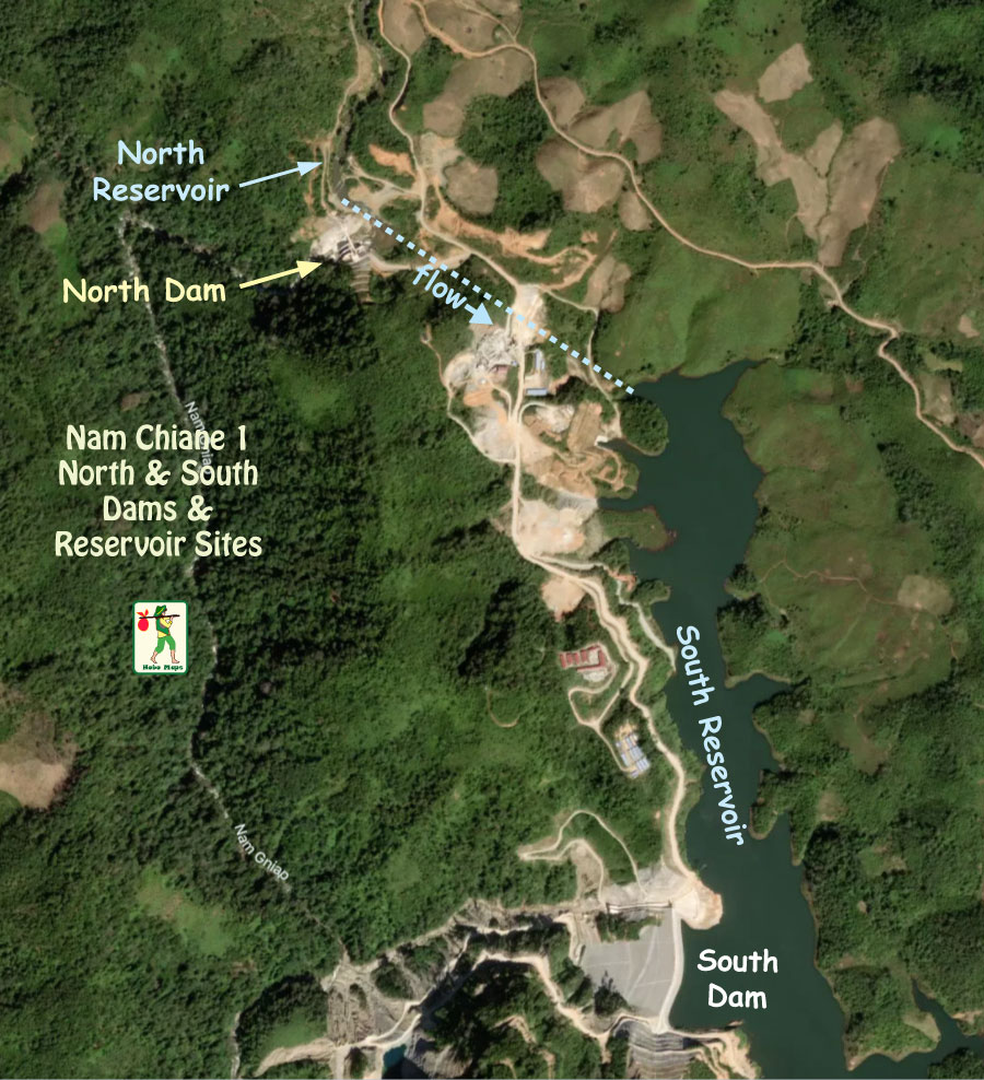
The project has a smaller North Dam with small reservoir that feeds water into a larger South Dam and reservoir.
Nam Chiane 1 South Dam and reservoir image below:
Nam Chiane 1 HPP is on the southern Xieng Khouang Plateau with terrain higher in the north and lower in the south. Elevation at the dam site is generally 900 to 1300 meters above sea level while the lower power plant site to the south is 450 to 500 meters above sea level. The project has a gross head of about 600 meters.
The project sites go from Keosed village in Khoun district, Xieng Khouang province to Samkothong village in Thathom district, Xaysomboun province. The main South Dam is located in Xieng Khoung Province while the powerhouse is in Xaysomboun Province.
Nam Chiane 1 HPP location is seen at the lower section of the map below:
The project powerhouse has installed capacity of 104 MW (2 x 52 MW vertical Pelton turbine sets) with energy output capacity of 451 GWh per year.
Nam Chiane 1 project layout image below - not to scale and north is not at top:

Nam Chiane 1 layout image below with North Dam structure at coordinates 19°09'45.3"N 103°32'52.3"E (19.162583, 103.547861) and South Dam structure near coordinates 19°08'45.7"N 103°33'18.4"E (19.146028, 103.555111) but not exact:

Construction of Nam Chiane 1 HPP began in 2013 and was completed in March 2018. Project cost was estimated at about US$ 250 million.
The project was originally owned by Electricite du Laos (EDL) but we have a later report that it was transferred to EDL GEN. However in October 2026 we do not see it listed on the EDL GEN website as one of their projects, either as wholly-owned or as having any interest at all. In October 2026 now unsure who the owner might be.
China Gezhouba Group International Engineering Company Limited was the project developer pursuant to an engineering, procurement and construction contract signed December 2012.
The power generated was originally offtaken by EDL and transmitted to the Thavieng Substation for local consumption mainly in Xieng Khouang Province. A later report in 2024 indicates there are plans for export of some output to Vietnam. Another August 2025 report by a Vietnamese company reveals plans to import power from Nam Chiane 1 into Vietnam's 220 kV Tuong Duong substation. Not sure which is the case in 2026 but it would be unusual for EDL GEN as 100% owner of Nam Chiane 1 to be exporting and selling all of its power output to Vietnam.
Nam Chiane 1 HPP powerhouse site images below - located at coordinates 19°03'54.8"N 103°31'16.4"E (19.065210, 103.521220):


The project includes a rock-filled dam with clay core 93 meters high and 294 meters long, a flushing sluice, access tunnels, power plant buildings and switching stations. The surge tower is 110 meters high and 10 meters in diameter.
The watershed area for the north dam site on the Nam Chiane river is 281 square km. Watershed area of the south dam site on Nam Tong Sai river is 41 square km and the combined watersheds are 322 square km.
A smaller North Reservoir holds water that is channeled down to the larger South Reservoir in a tunnel 533 meters long. The combined capacity of the two reservoirs is 14 million cubic meters.
The headrace tunnel is 7,390 meters long while the penstock is 2,525 meters long.
Nam Chiane 1 penstock, powerhouse & switch yard images below:


Nam Chiane 1 South Dam & South Reservoir image below:

North Dam & Reservoir image below:
Nam Chiane 1 penstock image below:

Nam Chiane 1 control images below:


Nam Chiane 1 control room below:

Nam Chiane 1 powerhouse interior image below:

Nam Chiane 1 intake structure image below for South reservoir where water goes down to the powerhouse.

Nam Chiane 1 intake structure below conveys water from North Reservoir down to South Reservoir.

Nam Chiane 1 discharge tailrace channel image below:

Headrace tunnel adit entrance image below:

Nam Chiane 1 channel image shown below:

North Reservoir
Transmission line for transfer of output is a two circuit 115 kv line to Thavieng Substation.
Nam Chiane 1 South Reservoir image below:

Nam Chiane 1 switchyard image below.

Nam Chiane 1 Project is shown on right side of map below:
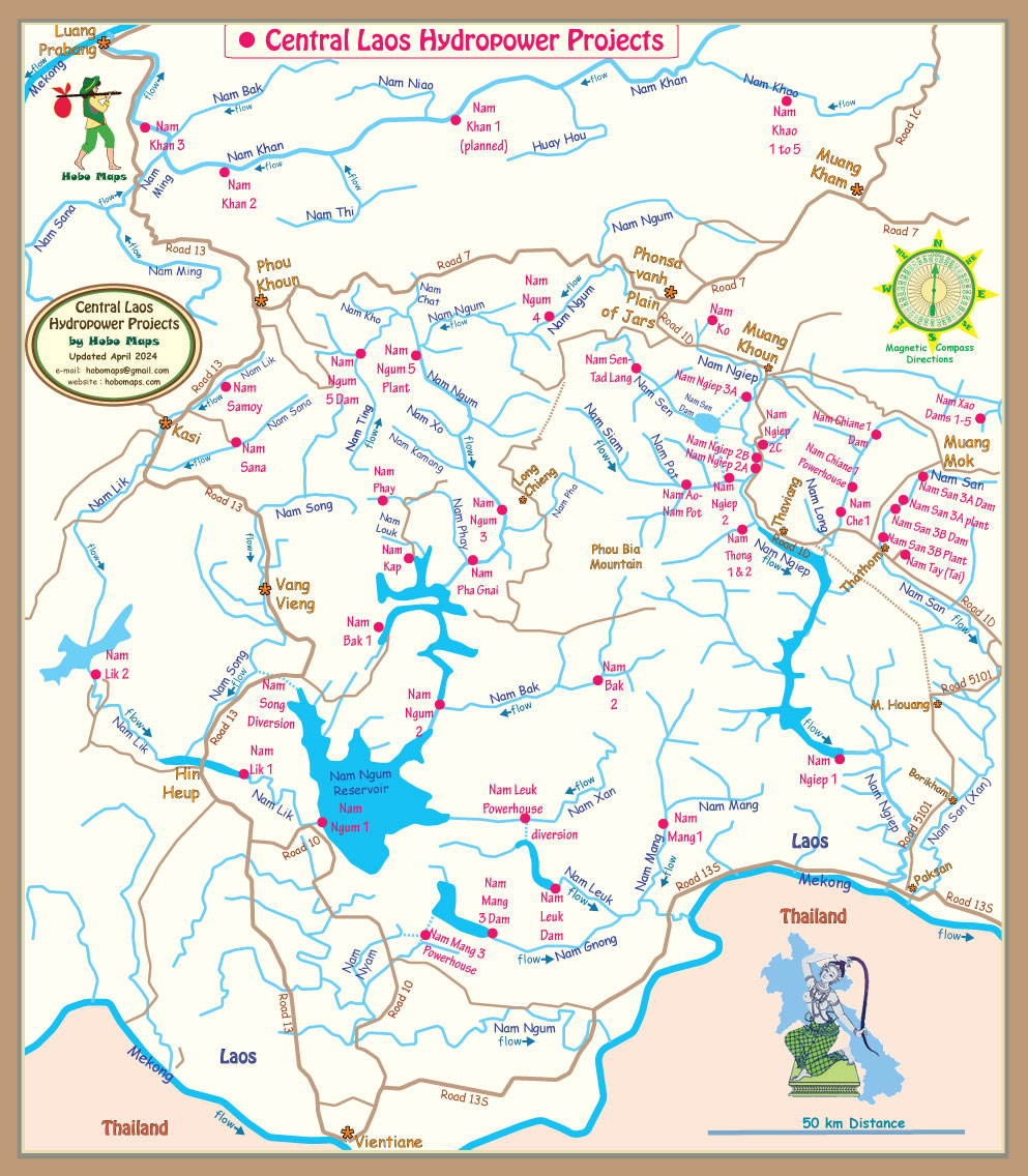
Click HERE to see our hydropower web page for the greater Nam Ngiep catchment basin which describes the various dams, reservoirs and diversion projects in the drainage basin which are often inter-connected.
Watershed maps below show Nam Chian(e) and Nam Ngiep Hydropower Projects:


Nice 2022 video of Nam Chiane 1 hydropower project HERE .

Map below for Nam Ngiep River Basin hydropower projects:

