Luang Prabang Flood info by Hobo Maps - Go to Hydropower Projects Page - - Home
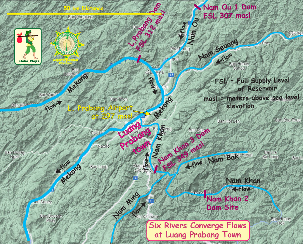
Seems like Luang Prabang town is in a flood-prone area. From the area map below we can see waters from six rivers converging and flowing past L. Prabang town.

3 flood maps below show the areas of L. Prabang that might be inundated when Mekong River surface level waters rise to 290, 295 & 300 meters above sea level (masl). These are estimates only made with unverified data and cannot be relied on for accuracy. Not usable in an actual emergency when temporary flood-control measures are in place.
Flooded area with Mekong at 290 meters above sea level below:
Flooded area with Mekong at 295 meters above sea level below:
Flooded area with Mekong at 300 meters above sea level below:
Map below show the central areas of L. Prabang that would be inundated when flood waters are at 300 meters above sea level.
Shocking to see that about 95% of L. Prabang accommodation would be inundated when Mekong rises to 300 masl. We wonder where the guests at these facilities would be relocated to until the waters recede. A contingency plan would seem necessary to timely notify guests and accommodation owners of flood potential.
With the completion of the Nam Ou Cascade of seven hydropower projects and the Nam Kham 2 and 3 dams as well as the start of construction for the Mekong mainstream Luang Prabang dam we wonder if the chances of future flooding in L. Prabang town will be more likely or less likely.
The ownriver Sayaboury Dam reservoir south of L. Prabang has created a backwater pond that raises the level of the Mekong at L. Prabang town to a constant level of 275 meters above sea level. This may act as a reducer of the amount and speed of floodwaters draining from L. Prabang on the Mekong and thus increase the elevation and time of flooding at the town.
Nam Khan 2 & 3 HPP have large reservoirs and may be able to temporarily halt outflows on the Nam Khan down to LP town and shift to storage. Nam Ou 1 to 7 dams also may reduce flows.
Mekong mainstream L. Prabang and Sayaboury dams aren't designed to hold back more water but with timely communication they could release water in advance when predictions of a flood surge are made.
Nam Seuang has no dams and is uncontrolled now but two dams have been in the planning stage for some time already.
Causes of a flood can be natural flows, lack of plans, poor plans, communication failures, human error, dam structure breaches, earthquakes, greed and saboutage,
There seems to be a need for a serious discussion about how authorities and businesses could best handle a flood situation. A comprehensive and detailed flood reaction plan would be useful to reduce the chances of flooding and make flood emergency plans.
Also a need for hydropower dam projects to work together and take combined action to mitigate flood effects or eliminate a flood threat.
Detailed data for Mekong river flows and capacity is now available on a timely basis and there's a good ability to predict a flood threat in time for mitigation measures to be coordinated.
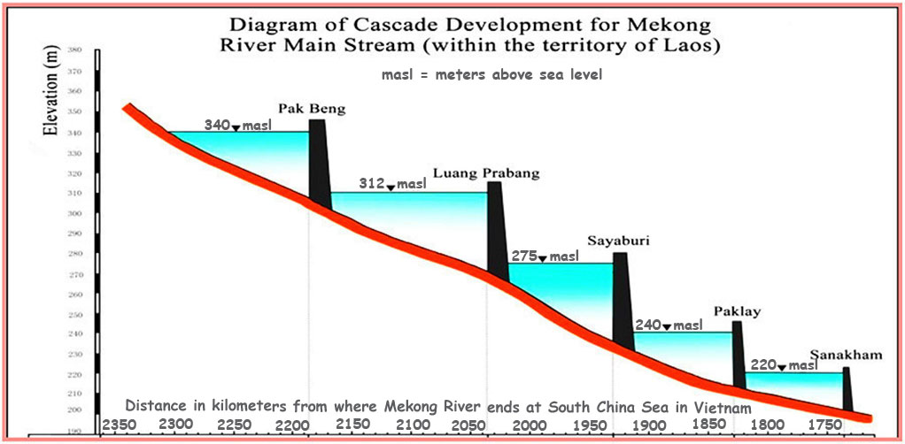
- located 25 km upstream from Luang Prabang town near Pak Ou
- site coordinates are 20°04'24.7"N 102°11'15.0"E (20.073528, 102.187500)
- site construction is underway in 2022 and major facility construction should start in 2023 and maybe completed by 2028 or later
- owner is Luang Prabang Power Company Limited
- reservoir surface level is planned to be held at a constant 312 meters above sea level which is 37 meters higher than the 275 masl of the Mekong at L. Prabang town as created by the backwater pond of the existing downriver Sayaboury Dam.
Also see our detailed web page for Luang Prabang Dam
-----------------------------
Flood-prone L. Prabang - In 2008 I was in L. Prabang when there was very high water in the Mekong and Nam Khan rivers that spilled onto lower area streets without doing any serious damage. A year or two later I witnessed the Nam Khan 3 Dam hydropower project experience a construction dam breach that sent water and debris rushing down past L. Prabang which caused all boat traffic to be halted on the Mekong for a day. Again luckily no injuries or major damage but some lower streets were flooded.